Just back from this walk in Victoria. Had good weather and a great time - with 4 of my kids...
Tony Robinson
Beeripmo Walk
Forum rules
Posting large/multiple images in this forum is OK. Please start topic titles with the name of the location or track.
For topics focussed on photos rather than the trip, please consider posting in the 'Gallery' forum instead.
This forum is for posting information about trips you have done, not for requesting information about a track or area.
36 posts
• Page 1 of 2 • 1, 2
Beeripmo Walk
![]() by Robbo » Sat 27 Sep, 2008 9:05 am
by Robbo » Sat 27 Sep, 2008 9:05 am
- Attachments
-
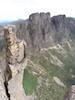
- Looking NW from Cave Rock
- Beeripmo3.png (621.95 KiB) Viewed 40887 times
-
- Looking S from Mount Buangor
- Beeripmo5.png (596.45 KiB) Viewed 40887 times
-
- On top of Mount Buangor
- Beeripmo6.png (844.94 KiB) Viewed 40873 times
"The place between your comfort zone and your dream is where your life takes place." Nick Vujicic.
-
Robbo - Athrotaxis cupressoides

- Posts: 288
- Joined: Sat 07 Jun, 2008 8:31 pm
- Location: Melbourne
- ASSOCIATED ORGANISATIONS: Gilson College
- Region: Victoria
- Gender: Male
Re: Beeripmo Walk
![]() by neil_fahey » Tue 15 Dec, 2009 2:37 pm
by neil_fahey » Tue 15 Dec, 2009 2:37 pm
Looks beautiful Tony!
Hope you don't mind answering a few questions I've got...
Had you done this one before?
Is it the same as the walk described here - http://www.dse.vic.gov.au/CA256F310024B ... o+Walk.pdf?
Which map did you use?
Was it mostly worn tracks or did you have to go bush-bashing and just use a compass & map to figure out where to go?
Thanks!
Neil
-

neil_fahey - Athrotaxis cupressoides
- Posts: 215
- Joined: Mon 14 Dec, 2009 12:30 pm
- Location: Melbourne, Victoria
- ASSOCIATED ORGANISATIONS: BushwalkingBlog.com.au
- Region: Victoria
- Gender: Male
Re: Beeripmo Walk
![]() by Robbo » Wed 16 Dec, 2009 1:41 pm
by Robbo » Wed 16 Dec, 2009 1:41 pm
No worries, Neil.
No, I hadn't done it before. I read about it in Wild and used the description you used. I have since purchased a Beauford 1:50000 map for the area as we take our school students out there now.
It is tracked and well marked with a specific logo at any track or road crossing you come to.
It is an enjoyable walk. Hope you get the chance to do it.
TR
"The place between your comfort zone and your dream is where your life takes place." Nick Vujicic.
-
Robbo - Athrotaxis cupressoides
- Posts: 288
- Joined: Sat 07 Jun, 2008 8:31 pm
- Location: Melbourne
- ASSOCIATED ORGANISATIONS: Gilson College
- Region: Victoria
- Gender: Male
Re: Beeripmo Walk
![]() by neil_fahey » Wed 16 Dec, 2009 2:19 pm
by neil_fahey » Wed 16 Dec, 2009 2:19 pm
Thanks heaps... Another one to add to the list for sure!
-
neil_fahey - Athrotaxis cupressoides
- Posts: 215
- Joined: Mon 14 Dec, 2009 12:30 pm
- Location: Melbourne, Victoria
- ASSOCIATED ORGANISATIONS: BushwalkingBlog.com.au
- Region: Victoria
- Gender: Male


Re: Beeripmo Walk
![]() by ChrisC » Mon 21 Dec, 2009 7:17 pm
by ChrisC » Mon 21 Dec, 2009 7:17 pm
This is a great 22km circuit walk with great views and a variety of grades and vegetation. There is little running water but well kept camp spots with water nearby ( if you are ok with the taste) and drop toilets. Well worth the effort to get there.
- ChrisC
- Nothofagus cunninghamii

- Posts: 5
- Joined: Sat 18 Jul, 2009 6:52 pm
- Gender: Male
Re: Beeripmo Walk
![]() by trickos » Mon 03 Oct, 2011 4:19 pm
by trickos » Mon 03 Oct, 2011 4:19 pm
I have recently completed this walk in a day on the coldest, wettest most miserable September day imaginable. However I loved every minute of it.
Started about 9.30 am from Richards Campground where the wind was pretty sheltered and reasonable weather. Not long after Raglan Falls the weather closed in and the wind picked up to give it an unbelievable
wind chill with a spot of rain. The promised brilliant views to the west were nothing more than a white out unfortunately. It was even too cold to stop for any length of time.
I arrived at the designated campsite - Beeripmo Campground around 12.30 very soggy and very cold. It looked lovely in the mist. Some hearty campers were nearing commencing the 2nd day of the hike. I scoffed my lunch and headed to hopefully more shelter and drier conditions. What luck!!!!
Approaching Mugwamp Camp I noticed 4 ranger vehicles about ready to depart from the hut and smoke from the chimney. They all departed and left the huts fireplace fully ablaze which I immediately took advantage of. I could not believe it.
Downhill walking all the way from here - a few lovely creek crossings and really nice single track hiking. A great walk - very well marked - highly recommend it to anyone wanting a serious day adventure or an intro to overnight walking. Unfortunately I could not find a good topo map of the area although the DSE map (I think someone else has made a link) was very useful.
Started about 9.30 am from Richards Campground where the wind was pretty sheltered and reasonable weather. Not long after Raglan Falls the weather closed in and the wind picked up to give it an unbelievable
wind chill with a spot of rain. The promised brilliant views to the west were nothing more than a white out unfortunately. It was even too cold to stop for any length of time.
- en route to sugaloaf.JPG (54.51 KiB) Viewed 38403 times
I arrived at the designated campsite - Beeripmo Campground around 12.30 very soggy and very cold. It looked lovely in the mist. Some hearty campers were nearing commencing the 2nd day of the hike. I scoffed my lunch and headed to hopefully more shelter and drier conditions. What luck!!!!
Approaching Mugwamp Camp I noticed 4 ranger vehicles about ready to depart from the hut and smoke from the chimney. They all departed and left the huts fireplace fully ablaze which I immediately took advantage of. I could not believe it.
Downhill walking all the way from here - a few lovely creek crossings and really nice single track hiking. A great walk - very well marked - highly recommend it to anyone wanting a serious day adventure or an intro to overnight walking. Unfortunately I could not find a good topo map of the area although the DSE map (I think someone else has made a link) was very useful.
- Attachments
-
-
-

trickos - Athrotaxis cupressoides
- Posts: 101
- Joined: Mon 08 Feb, 2010 2:55 pm
- Location: Geelong
- Region: Victoria
- Gender: Male
Re: Beeripmo Walk
![]() by sim1oz » Thu 29 Dec, 2011 10:31 pm
by sim1oz » Thu 29 Dec, 2011 10:31 pm
Thanks to this thread, we decided to do the Beeripmo Walk as our introduction to overnight walking in November, hoping for some nice Spring sunshine. We took the Monday off work and turned the Cup Day public holiday into a long weekend, so that we could have some quality time with our 13yo son. We arrived after dark and camped Sunday night at the start of the trail with the good intentions of making an early start the next morning. I was surprised at how busy things were Cup weekend at Richards Camp, with several tents and even some solar fairy lights adorning the large eating pavilion. As things worked out, we didn’t get the ‘early’ start we had planned. Eating breakfast and packing up took longer than expected, but because this was all part of the ‘experience’ of transitioning from day walking to backpacking and we didn’t have far to walk on Day One, we were fairly relaxed about it all.
Our navigation aids included a compass, an altimeter watch, and the following:
1. Forests Notes from DSE http://www.dse.vic.gov.au/__data/assets/pdf_file/0016/101914/Beeripmo_Walk.pdf
2. Vicmap BEAUFORT 7523-S 1:50, 000 topographic map
3. Detailed walk notes (p226-233) from “Bushwalking in Australia” (2003, 4th edn) by John Monica Chapman, which includes a 1:25,000 topographic map. http://www.john.chapman.name/pub-aus.html
In hindsight, we could have simply carried the Chapman notes, which we did consult from time to time. Despite being published in 2003, the notes are still very accurate. The only change we picked up is that the cliff edge above Raglan Falls is now fenced. The walk from Richards Camp up to Beeripmo Camp was fairly straight forward, though there were a few spots with several paths and no clear signage indicating which was the Beeripmo trail. This is when the compass and Chapman’s map came in very handy! The altimeter watch helped us track our progress on the path via the contour levels. In fact, our son took ownership of my watch and hiking poles quite early on and they kept him occupied. He tracked all our statistics, including altitude, temperature, walk time, rest time, etc. He also enjoyed racing ahead like a mountain goat then lounging around until we caught up, to be greeted with comments regarding our pace.
Day One, the weather was overcast and mild. We started out with beanies and windshirts but soon warmed up. As we climbed higher, mist rolled in and the temperature dropped. Provided we kept moving, we were ok but it was cold. We arrived at Beeripmo Camp in time for a latish lunch, set up camp and built a fire in the fire ring at our site. The toilet block was rustic and clean, and the water tank was full. Another hiker arrived around 6pm and was surprised to see he had some company. We sat around the fire trying to fight away the chill in the air. After roasting marshmallows we called it a night, put out the fire, and climbed into our sleeping bags. It rained throughout the night, not heavy but constant. None of us slept well because of the bitter cold, despite wearing all our layers of clothing and 2+ pairs of socks. We are glad we tested our gear on a short trip and everything held up fine but new, warmer (and lighter) sleeping bags have been put on the shopping list!!!
Day Two, it was still raining so we ate a quick breakfast in the tent, got ready and raced to the toilet block where we packed up our tent undercover. As we made our way along Mugwamp Track, the rain finally stopped but the fog was quite thick. When we reached the turnoff to the Mt Buangor Lookout we were disappointed to see a red sign saying that the State Park was closed to the public due to a recent fire. It wasn’t clear whether the restriction was still in force (it referred to the April school holidays and Easter period) but we decided to give the climb a miss because we weren’t sure and it looked like the rain was about to start again. We rested in the hut at Mugwamp Camp and enjoyed the heat of a small fire with glowing coals. Perhaps a gift from friendly rangers, as per the previous post? The remainder of the walk was actually quite quick and we lunched in the eating pavilion at Richards camp.
Chapman rates the Beeripmo Walk as Easy, but we would be more inclined to rate it at the easy end of Medium simply because of the climbing involved. Having said that, I believe most walkers could do the entire trail in a day because it is not very long. (To put it in perspective, we are at the fit end of beginners and do lots of day walks.) The walk did prove to be a great introduction to overnight hiking.
Our navigation aids included a compass, an altimeter watch, and the following:
1. Forests Notes from DSE http://www.dse.vic.gov.au/__data/assets/pdf_file/0016/101914/Beeripmo_Walk.pdf
2. Vicmap BEAUFORT 7523-S 1:50, 000 topographic map
3. Detailed walk notes (p226-233) from “Bushwalking in Australia” (2003, 4th edn) by John Monica Chapman, which includes a 1:25,000 topographic map. http://www.john.chapman.name/pub-aus.html
In hindsight, we could have simply carried the Chapman notes, which we did consult from time to time. Despite being published in 2003, the notes are still very accurate. The only change we picked up is that the cliff edge above Raglan Falls is now fenced. The walk from Richards Camp up to Beeripmo Camp was fairly straight forward, though there were a few spots with several paths and no clear signage indicating which was the Beeripmo trail. This is when the compass and Chapman’s map came in very handy! The altimeter watch helped us track our progress on the path via the contour levels. In fact, our son took ownership of my watch and hiking poles quite early on and they kept him occupied. He tracked all our statistics, including altitude, temperature, walk time, rest time, etc. He also enjoyed racing ahead like a mountain goat then lounging around until we caught up, to be greeted with comments regarding our pace.
- Looking out from the cliff over Raglan Falls
Day One, the weather was overcast and mild. We started out with beanies and windshirts but soon warmed up. As we climbed higher, mist rolled in and the temperature dropped. Provided we kept moving, we were ok but it was cold. We arrived at Beeripmo Camp in time for a latish lunch, set up camp and built a fire in the fire ring at our site. The toilet block was rustic and clean, and the water tank was full. Another hiker arrived around 6pm and was surprised to see he had some company. We sat around the fire trying to fight away the chill in the air. After roasting marshmallows we called it a night, put out the fire, and climbed into our sleeping bags. It rained throughout the night, not heavy but constant. None of us slept well because of the bitter cold, despite wearing all our layers of clothing and 2+ pairs of socks. We are glad we tested our gear on a short trip and everything held up fine but new, warmer (and lighter) sleeping bags have been put on the shopping list!!!
- Beeripmo Camp - water, toilets, camp sites, camp platform
- Enjoying the camp fire with something sweet
Day Two, it was still raining so we ate a quick breakfast in the tent, got ready and raced to the toilet block where we packed up our tent undercover. As we made our way along Mugwamp Track, the rain finally stopped but the fog was quite thick. When we reached the turnoff to the Mt Buangor Lookout we were disappointed to see a red sign saying that the State Park was closed to the public due to a recent fire. It wasn’t clear whether the restriction was still in force (it referred to the April school holidays and Easter period) but we decided to give the climb a miss because we weren’t sure and it looked like the rain was about to start again. We rested in the hut at Mugwamp Camp and enjoyed the heat of a small fire with glowing coals. Perhaps a gift from friendly rangers, as per the previous post? The remainder of the walk was actually quite quick and we lunched in the eating pavilion at Richards camp.
- Mugwamp Camp - toilet, picnic table, hut, camp sites
Chapman rates the Beeripmo Walk as Easy, but we would be more inclined to rate it at the easy end of Medium simply because of the climbing involved. Having said that, I believe most walkers could do the entire trail in a day because it is not very long. (To put it in perspective, we are at the fit end of beginners and do lots of day walks.) The walk did prove to be a great introduction to overnight hiking.
-

sim1oz - Athrotaxis cupressoides
- Posts: 459
- Joined: Mon 17 Jan, 2011 10:15 pm
- Region: Victoria
- Gender: Female
Re: Beeripmo Walk
![]() by danpickard » Mon 23 Jan, 2012 4:37 pm
by danpickard » Mon 23 Jan, 2012 4:37 pm
Thanks for the good reports. Also been looking at this one as a good intro for our kids to overnighting it (two lots of twins, aged 4 & 7). They've managed day walks at nearly 10km, but they didn't have to carry a pack. Would be nice to get them atleast to carry a sleeping bag and water for themselves. The hike both local for me (not far from Geelong), and also looks to be quite suitable for kids (few "modern ammenities" so it doesn't feel too rough on the kids). Certainly looks a well maintained loop. Need to get ourselves another tent though...6 in one makes it a squeeze!
Cheers,
Dan Pickard
Cheers,
Dan Pickard
-

danpickard - Nothofagus gunnii

- Posts: 11
- Joined: Wed 02 Mar, 2011 4:40 pm
- Region: Victoria
- Gender: Male
Re: Beeripmo Walk
![]() by Bronski » Wed 25 Jan, 2012 1:57 pm
by Bronski » Wed 25 Jan, 2012 1:57 pm
sim1oz wrote: We arrived after dark and camped Sunday night at the start of the trail with the good intentions of making an early start the next morning.
Can you tell me how far it is from the cars to the campground at the Richards camp ground (Beeripmo Trailhead). I have read differing accounts of a 1km walk, to car based camping! Need to know how best to pack the camp gear as we are base camping at Richards to do the Beerpmo in a day. Thanks!
-

Bronski - Nothofagus gunnii
- Posts: 48
- Joined: Mon 10 Jan, 2011 8:19 am
- Location: Melbourne
- Region: Victoria
- Gender: Female
Re: Beeripmo Walk
![]() by sim1oz » Wed 25 Jan, 2012 2:09 pm
by sim1oz » Wed 25 Jan, 2012 2:09 pm
Hi Bronski,
The car park is right next to Richards Camp (separated by a little bridge over the creek), so depending on where you park your car and where you pitch your tent it would be 10-50m between the two so definitely base camping style if you are going to do the walk in one day.
Enjoy!
Simone
The car park is right next to Richards Camp (separated by a little bridge over the creek), so depending on where you park your car and where you pitch your tent it would be 10-50m between the two so definitely base camping style if you are going to do the walk in one day.
Enjoy!
Simone
Carpe diem!
-
sim1oz - Athrotaxis cupressoides
- Posts: 459
- Joined: Mon 17 Jan, 2011 10:15 pm
- Region: Victoria
- Gender: Female
-
Bronski - Nothofagus gunnii
- Posts: 48
- Joined: Mon 10 Jan, 2011 8:19 am
- Location: Melbourne
- Region: Victoria
- Gender: Female
Re: Beeripmo Walk
![]() by sim1oz » Wed 25 Jan, 2012 2:15 pm
by sim1oz » Wed 25 Jan, 2012 2:15 pm
@Dan. With two lots of twins in 3-4 years you deserve a medal for walking out the front door!
Depending on their walking stamina, your littlies might need to take a few scenic rest breaks as there is a lot of walking up and down inclines which could be tiring for short legs. There are no rock scrambles or narrow ledges so nothing to fear. It was fun
Depending on their walking stamina, your littlies might need to take a few scenic rest breaks as there is a lot of walking up and down inclines which could be tiring for short legs. There are no rock scrambles or narrow ledges so nothing to fear. It was fun
Carpe diem!
-
sim1oz - Athrotaxis cupressoides
- Posts: 459
- Joined: Mon 17 Jan, 2011 10:15 pm
- Region: Victoria
- Gender: Female
Re: Beeripmo Walk
![]() by danpickard » Thu 26 Jan, 2012 8:27 am
by danpickard » Thu 26 Jan, 2012 8:27 am
Hi Simone,
The kids have surprising stamina when they want too! We've done a lot of the Lorne/Otways walks with them (longest about 10 km), and they've held up for most of the walk (although a bit of a shuffle by the end of it), and they are fairly happy to scuff around the You Yangs circuit with a bit of dust and scramble. We would probably only take the older pairs of legs initially to test the waters with them. More of a concern would be how many times they say "I'm hungry, I'm thirsty, I need to pee"
Cheers,
Dan
-
danpickard - Nothofagus gunnii
- Posts: 11
- Joined: Wed 02 Mar, 2011 4:40 pm
- Region: Victoria
- Gender: Male
Re: Beeripmo Walk
![]() by sim1oz » Fri 27 Jan, 2012 3:35 pm
by sim1oz » Fri 27 Jan, 2012 3:35 pm
Hi Dan,
Sounds like the walk will be perfect for your kids. Drink/pee stops are the perfect time to rest and enjoy the scenery !
Enjoy,
Simone
Sounds like the walk will be perfect for your kids. Drink/pee stops are the perfect time to rest and enjoy the scenery
Enjoy,
Simone
Carpe diem!
-
sim1oz - Athrotaxis cupressoides
- Posts: 459
- Joined: Mon 17 Jan, 2011 10:15 pm
- Region: Victoria
- Gender: Female
Re: Beeripmo Walk
![]() by Explorer_Sam » Sat 31 Mar, 2012 9:55 pm
by Explorer_Sam » Sat 31 Mar, 2012 9:55 pm
I walked this track as an introduction to overnight hiking when I was 12. It was only 2 years ago so it's still fresh in my mind and it was one of my favourite walks. Great walk and fantastic scenery.
Explorer_Sam.
Explorer_Sam.
My Blog- Adventure and Nature Writing- www.sambochristie.wordpress.com
- Explorer_Sam
- Athrotaxis cupressoides
- Posts: 313
- Joined: Thu 01 Mar, 2012 8:33 pm
- Location: Maryborough
- Region: Victoria
- Gender: Male
Re: Beeripmo Walk
![]() by bmak » Tue 03 Apr, 2012 9:53 pm
by bmak » Tue 03 Apr, 2012 9:53 pm
I plan on doing this over the coming long weekend.
I've covered most of the sections over the years but never done the lot as a complete walk so planning to do it as a day trip.
I've covered most of the sections over the years but never done the lot as a complete walk so planning to do it as a day trip.
- bmak
- Athrotaxis cupressoides
- Posts: 150
- Joined: Sun 13 Jun, 2010 8:26 pm
- Region: Victoria
- Gender: Male
Re: Beeripmo Walk
![]() by Snowzone » Wed 04 Apr, 2012 10:54 am
by Snowzone » Wed 04 Apr, 2012 10:54 am
bmak wrote:I plan on doing this over the coming long weekend.
I've covered most of the sections over the years but never done the lot as a complete walk so planning to do it as a day trip.
Brad, this walk makes a great day walk as well as a good overnighter.
I have taken a few people including children on this walk for their first overnight experience. Most people seem to walk in a clockwise direction but for children I do it anti-clockwise that way if it does get a bit too much for them you can stop and camp at Mugwamp instead. There is also a hut at Mugwamp if the weather is no good.
-

Snowzone - Phyllocladus aspleniifolius

- Posts: 519
- Joined: Sat 11 Dec, 2010 12:10 pm
- Region: Victoria
- Gender: Female
Re: Beeripmo Walk
![]() by bmak » Mon 09 Apr, 2012 9:52 pm
by bmak » Mon 09 Apr, 2012 9:52 pm
Probably didn't choose the best day today to do the complete walk.
Rain, strong wind and some hail for the first half but even though i didn't have any wet gear with me i braved the conditions.
Traveled clockwise and made a quick stop at Mugwamp Hut for lunch. By the time i was ready to go again the rain cleared and i actually saw some sunshine on the final section.
Was glad to see the fire going at Richards Campground upon return so i was able to get warm and dry before leaving.
Did the entire trip in around 4 1/2 Hrs and will be sure to do it again in some nicer weather soon and maybe stay overnight.
Track is still clear and well marked with plenty of new signage. I noticed a lot of the surrounding tracks now seem to be clear and open to the public again as well.
- Attachments
-
- bmak
- Athrotaxis cupressoides
- Posts: 150
- Joined: Sun 13 Jun, 2010 8:26 pm
- Region: Victoria
- Gender: Male
Re: Beeripmo Walk
![]() by jeza » Wed 09 May, 2012 10:37 pm
by jeza » Wed 09 May, 2012 10:37 pm
Did this walk on the weekend. After some more challenging walks like climbing Staircase Spur to Mt Bogong, this easier walk was quite refreshing. We had an early lunch at Richards before walking along the ferny gully of Cave Hill Creek via Raglan Falls. The views were nice around Cave Hill, though by the time we got to Sugarloaf Lookout all we could see was white. None the less, it have a slightly mystical feeling walking through a forest that's partially shrouded in cloud. The hills along this section of the hike still gave us plenty of exercise, indeed my GPS recorded a total of around 900m of ascent for the weekend. Arriving at the campground in time to pitch the tents in daylight and collect some firewood, we only faced one problem! Everything was damp and wet. Still with a bit of persistence we got the campfire going which became one of the most enjoyable aspects of the trip.
After a bit of a sleep in, the fog cleared in the morning. We left our packs hidden in the bushes while we climbed up Mt Buangor with good views to the Grampians, Mt Elephant (I think) and a Wedge-tailed Eagle circling the sky. The later was really neat. Returned to our packs to find a few leeches had climbed onto the packs and were waiting for us, yet miraculously no one got any bites. Had lunch at Mugwamp before making the stroll back down to Richards.
Though it's advertised as a two day walk, I would say two half days are more accurate. I did have reservations about doing such a short walk overnight but it worked well starting in the middle of the day. I also preferred camping away from cars, etc.
- jeza
- Nothofagus cunninghamii
- Posts: 8
- Joined: Mon 30 Apr, 2012 3:15 pm
- Region: Victoria
- Gender: Male
Re: Beeripmo Walk
![]() by dplanet » Tue 15 May, 2012 10:23 pm
by dplanet » Tue 15 May, 2012 10:23 pm
Planned Beeripmo Walk last year; but could not do it due to track closure; therefore, I did daywalks. One of the walks was near Ferntree Picnic Area and the other included Grevillea & Paradise Tracks. Hopefully I will be able to do Beeripmo Walk again some time this year. Attached is a couple of pics taken in different occations.
- Attachments
-
- Mt Buangor in snow on solo walk in 2004.
- mt_buangor_01.jpg (264.8 KiB) Viewed 37329 times
-
- Langi Ghiran from Mt Buangor Forest on Federation Walk 2008. Had a nice time with walkers from Ballarat, Ben Cuanchan.. Sorry if I missed you. Photos: Dzung Nguyen
- fedwalk_1.jpg (185.05 KiB) Viewed 37329 times
-
- On solo walk up to Mt Buangor Lookout last year.
- 3.jpg (78.48 KiB) Viewed 37329 times
-

dplanet - Phyllocladus aspleniifolius
- Posts: 569
- Joined: Thu 04 Oct, 2007 8:21 pm
- Location: Ormond-Caulfield, Melbourne
- Region: Victoria
- Gender: Female
Re: Beeripmo Walk
![]() by lindsey » Fri 20 Jul, 2012 6:17 pm
by lindsey » Fri 20 Jul, 2012 6:17 pm
Was up there about three weeks ago doing the walk as a day trip and saw a big black pig on the track about 5 mins past the toilet block.
- lindsey
- Nothofagus gunnii
- Posts: 14
- Joined: Fri 11 Dec, 2009 8:38 pm
- Region: Victoria
- Gender: Female
Re: Beeripmo Walk
![]() by DB24 » Wed 27 Mar, 2013 9:04 am
by DB24 » Wed 27 Mar, 2013 9:04 am
Did this walk last weekend as an overnighter, starting at Richards Campground and camping at the Beeripmo Campground.
We walked in a clockwise direction and did about 10km the first day and 11km the second.
The track was well marked and very easy to follow, good views up top and it was nice to follow some creeks on the way down. I didn't count the number of cairns we saw, but there were lots, some of which looked to have been kicked over...
The Beeripmo campsite is well maintained with two drop toilets, a few fire rings and a rainwater tank. The only thing I would mention is that the tent sites are a gravel/dirt mix so if you have a thin tent bottom a groundsheet might be handy.
It got very windy in the night, so I was glad to be in my tarptent scarp which barely moved, although I was a bit hot with a 4c quilt. We estimated the temps got down to around 7c overnight (my friend was boiling in his -7c bag!). In the morning there were numerous sticks and small branches on the ground but none hit our tents (we of course looked up before picking a site).
It is a great overnighter for beginners or even intermediates looking for a quick circuit not too far from Melbourne.
- DB24
- Nothofagus gunnii
- Posts: 41
- Joined: Thu 23 Feb, 2012 3:07 pm
- Region: Victoria
- Gender: Male
Re: Beeripmo Walk
![]() by dplanet » Tue 09 Apr, 2013 10:01 pm
by dplanet » Tue 09 Apr, 2013 10:01 pm
I did the Beeripmo Walk two weeks ago and wrote up a report in my blog including the GPS route which is overlaid on the "Topo Memory-Map". For those, who missed the views due to weather conditions and/or who want the topo route map, here is the link
http://dztrek.blogspot.com.au/
http://dztrek.blogspot.com.au/
-
dplanet - Phyllocladus aspleniifolius
- Posts: 569
- Joined: Thu 04 Oct, 2007 8:21 pm
- Location: Ormond-Caulfield, Melbourne
- Region: Victoria
- Gender: Female
Re: Beeripmo Walk
![]() by Explorer_Sam » Sun 02 Jun, 2013 8:09 pm
by Explorer_Sam » Sun 02 Jun, 2013 8:09 pm
Hey all, my friend and I are planning to do this walk in the upcoming school holidays. I think this walk should be fairly suitable and easy to follow, even for two navigationally-challenged 16 year olds but I would like to be reassured so. Also note that we are fairly experienced and keen walkers but this will be our first overnight walk without parents holding our hands every step of the way.
Also, if anyone who has walked the track recently has any information on track conditions and water at the Beeripmo Campground, that would be greatly appreciated.
Thanks, Sam.
Also, if anyone who has walked the track recently has any information on track conditions and water at the Beeripmo Campground, that would be greatly appreciated.
Thanks, Sam.
My Blog- Adventure and Nature Writing- www.sambochristie.wordpress.com
- Explorer_Sam
- Athrotaxis cupressoides
- Posts: 313
- Joined: Thu 01 Mar, 2012 8:33 pm
- Location: Maryborough
- Region: Victoria
- Gender: Male
Re: Beeripmo Walk
![]() by sim1oz » Tue 04 Jun, 2013 8:37 pm
by sim1oz » Tue 04 Jun, 2013 8:37 pm
Hi Sam,
I haven't walked Beeripmo for over a year but it is pretty easy to follow in most parts with lots of orange arrows. There were only 2-3 spots where we had to think! The Chapman notes and map are all you need - photocopied and laminated. With all the rain we've been having, I don't think water would be an issue at Beeripmo Camp but it's always best to check with a ranger or Parks Vic.
Enjoy!
Carpe diem!
-
sim1oz - Athrotaxis cupressoides
- Posts: 459
- Joined: Mon 17 Jan, 2011 10:15 pm
- Region: Victoria
- Gender: Female
Re: Beeripmo Walk
![]() by bmak » Mon 10 Jun, 2013 9:17 am
by bmak » Mon 10 Jun, 2013 9:17 am
Track is very clear at the moment and in good condition but maybe a bit wet after rain.
Plenty of water at beeripmo and creek water at Richards,Raglan falls and Mugwamp if needed.
You will do the walk easy as an overnight so i suggest taking the side trip to mt Buangor and maybe cave hill and maybe even the glut to extend it a bit
Plenty of water at beeripmo and creek water at Richards,Raglan falls and Mugwamp if needed.
You will do the walk easy as an overnight so i suggest taking the side trip to mt Buangor and maybe cave hill and maybe even the glut to extend it a bit
- bmak
- Athrotaxis cupressoides
- Posts: 150
- Joined: Sun 13 Jun, 2010 8:26 pm
- Region: Victoria
- Gender: Male
Re: Beeripmo Walk
![]() by Snowzone » Mon 10 Jun, 2013 8:12 pm
by Snowzone » Mon 10 Jun, 2013 8:12 pm
Hi Sam,
glad to hear Dad's going to get a rest while your out with your mate. Water won't be a problem, tanks at Beeripmo, Ditchfields and Richards will have plenty of water in them but getting a fire going might be a bit of a challenge as its usually pretty wet up there at this time of year.
I havn't been up there for a couple of months and the only little bit that was overgrown then was between Freemans track and Mugwamp where bracken was a bit thick but track was still easy enough to follow.
Have fun and enjoy it.
-
Snowzone - Phyllocladus aspleniifolius
- Posts: 519
- Joined: Sat 11 Dec, 2010 12:10 pm
- Region: Victoria
- Gender: Female
Re: Beeripmo Walk
![]() by sim1oz » Mon 10 Jun, 2013 8:21 pm
by sim1oz » Mon 10 Jun, 2013 8:21 pm
Just did parts of the walk this weekend, and I agree with the above comments. Loads of water about. We didn't carry much. It's pretty easy to navigate - all the track signs are in place and only one fallen tree to climb over - in the sections we did. It's a relatively easy walk so if you split it over two days then the side trips Brad suggested sound good. It was chilly at Beeripmo Camp last night, even with a fire, so make sure you have warm gear. We took some newspaper, kindling and methylated spirits with us to help get our fire going. We brought firewood with us but hubby wouldn't let me pile it all into my backpack so it got left behind in the car, but there was plenty of bark and small branch pieces to collect while we walked. My kids were spoilt with roasted marshmallows for dessert and again in the morning waiting for breakfast. 
Carpe diem!
-
sim1oz - Athrotaxis cupressoides
- Posts: 459
- Joined: Mon 17 Jan, 2011 10:15 pm
- Region: Victoria
- Gender: Female
Re: Beeripmo Walk
![]() by Smeagle » Mon 10 Jun, 2013 11:55 pm
by Smeagle » Mon 10 Jun, 2013 11:55 pm
This walk still to this day goes down as one of my favourite getaway from society overnight walks, mind you i havnt been there for a few years now, isnt it always wet or is that just my bad timing of weather once again recommended Chapman's notes for this one
Dont Worry...
I'm Aiming For The Unknown...
I Shall Greet You On The Other Side..
I'm Aiming For The Unknown...
I Shall Greet You On The Other Side..
-

Smeagle - Atherosperma moschatum

- Posts: 52
- Joined: Fri 07 Jun, 2013 5:11 pm
- Location: High Country
- Region: Victoria
- Gender: Male
36 posts
• Page 1 of 2 • 1, 2
Return to VIC Trip Reports & Track Notes
Who is online
Users browsing this forum: No registered users and 12 guests